1. UNCLOS-ing the future
On March 4th, 2023, after years of arduous negotiations, a draft agreement for the conservation and sustainable use of marine biological diversity in areas beyond national jurisdiction was adopted under the realm of the United Nations Convention on the Law of the Sea (UNCLOS). The agreement, generally referred to as the “High Seas Treaty”, addresses a historical gap, by increasing funding for marine conservation, and seeks to achieve ocean-related goals of the 2030 Agenda and the Global Biodiversity Framework.
As the High Seas Treaty aims to protect 30% of Earth’s oceans by identifying, establishing, regulating, and monitoring vulnerable areas, we shed light on the challenges and opportunities for an increased role and uptake of space services and solutions in supporting the conservation and sustainable use of marine biological diversity under the newly adopted High Seas Treaty. It is thus important to stress the significance of monitoring and enforcement of new regulations and explore the role space-enabled services can play in providing support to ocean governance and conservation.
The Agreement will establish a new international authority for the high seas with its own secretariat, under the governance of an intergovernmental conference of parties and with the support of a new scientific and technical committee. While the establishment of a new international authority for the high seas and its secretariat is not directly linked to the space sector, space services & solutions can play a role in supporting the scientific and technical committee in its efforts to monitor and protect the high seas as well as inform states and other interested parties on the implementation status and effectiveness of the treaty provisions.
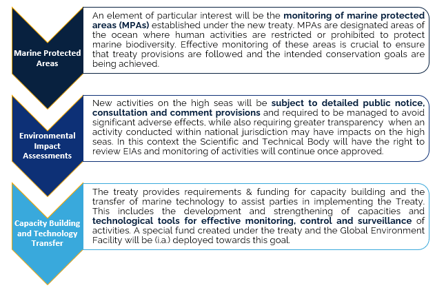
Article 39: “Parties shall, by using the best available science and scientific information, […] keep under surveillance the impacts of any activities in areas beyond national jurisdiction which they permit or in which they engage in order to determine whether these activities are likely to pollute or have adverse impacts on the marine environment.”
These potential opportunities stem from new mechanisms and requirements created under the treaty, including a process for designating marine protected areas (MPAs) and area-based tools to safeguard fragile, biodiverse areas. It also establishes ground rules for environmental impact assessments of commercial activities and arrangements for the equitable sharing of marine genetic resources.
Companies operating or exploiting space systems can play a critical role in supporting maritime domain awareness, identifying areas of the ocean that require protection, and improving monitoring and enforcement capabilities. Therefore, while the new agreement may have implications for the future development of space law and policy, the more imminent aspect is to showcase that space-enabled services can become a critical pillar in supporting ocean governance and conservation efforts.
2. The deep end of the High Seas Treaty: Space & Maritime Domain Awareness
The High Seas Treaty highlights the need for effective monitoring and enforcement of new regulations. It has long been suggested that the implementation of new marine protected areas and the emergence of UN treaties would necessitate the utilisation of satellite-based technologies and online data for effective enforcement.[1]
The demand for ocean monitoring services and maritime law enforcement has already led to markets serviced by companies exploiting various technologies, including Earth observation technologies, notably through optical and radar-based sensors, as well as Communications or Positioning Navigation Timing (PNT) based systems, such as Satellite–Automatic Identification Systems (S-AIS), or Long-Range Identification and Tracking (LRIT) and other Vessel Monitoring Systems (VMS). Some vessels may voluntarily participate in monitoring through the use of Cooperative technologies such (e.g. LRIT) while deploying and using Non-Cooperative technologies (e.g. Synthetic Aperture Radar (SAR), or SIGINT) are necessary for monitoring of non-compliant, often illegal operations.[2] Moreover, other (non-space) data sources such as onboard closed-circuit television systems and surveillance and monitoring drones can be leveraged by space solutions to build insights in state-of-the-art vessel monitoring systems.
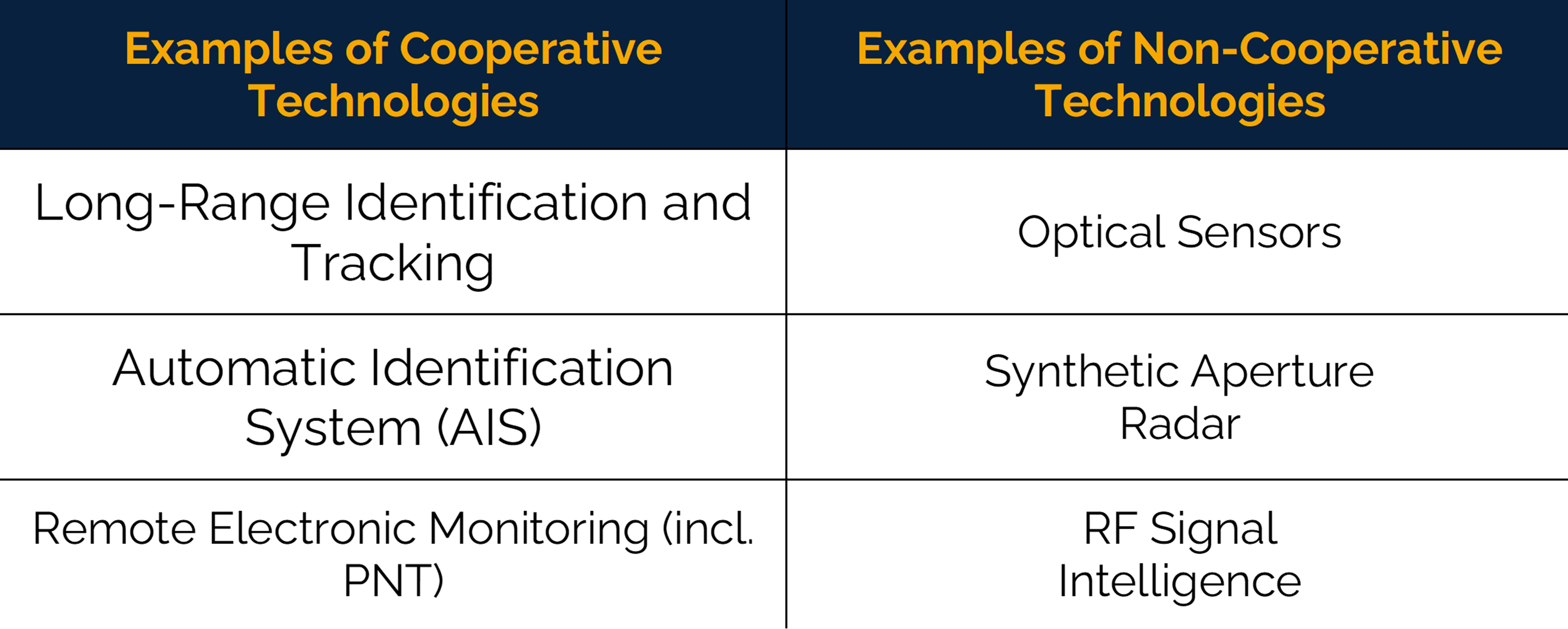
Various Vessel Monitoring Systems (VMS) and the Long Range Identification and Tracking System (LRIT) are satellite-enabled solutions for fulfilling regulatory requirements used to track the movements of commercial fishing vessels and are critical components of the regulatory framework governing maritime activities. These systems, however, have limitations in detecting non-cooperative vessels and, in such cases, Earth observation technologies and SIGINT are complementary tools that can provide additional information about vessel activities. By combining and integrating these different space technologies, regulators can gain a more comprehensive view of maritime activities and enforce regulations more effectively. The integration of in situ, ancillary data and IoT data with space-based data also allows efficient asset management, by enabling the application of the best platform/sensor combination to achieve the operational objective.
The Copernicus programme is likely to play a key role in monitoring the High Seas Treaty. Today, the Copernicus Marine Service, which is one of the six services provided by Copernicus, makes use of the Copernicus infrastructure and commercial assets to support organisations and decision-making related to ocean monitoring through the delivery of operational products. Among these, EUMETSAT operates the Sentinels specifically designed for the observation of oceans, i.e. Sentinel-3 and -6. The derived data, together with around 30 other missions from commercial, national, European, and international organisations provide the backbone satellite observations for the Copernicus Marine Service .
Additionally, the Copernicus services for Security applications provide information to respond to Europe’s security challenges in areas such as Border Surveillance, Maritime Surveillance, and Support to EU External Action. The Maritime Surveillance component of the service, overseen by the European Maritime Safety Agency (EMSA), provides information to support activities at sea, including fisheries control, maritime safety and security, customs, law enforcement, and marine environment pollution monitoring. Vessel Detection and LRIT are sub-services included in the Copernicus Maritime Surveillance component, which can be integrated with other in situ data to provide a close-to-real-time situational picture. However, the availability and use of in situ and ancillary data can be challenging, as timely and harmonized data must be available to support data processing & fusion and yield consistent results to provide increased situational awareness.
As showcased by Copernicus Services and existing commercial offerings, their current and often isolated use will be insufficient to ensure the effective implementation of the High Seas Treaty. To develop an efficient approach to ocean monitoring, the integration of these technologies into interoperable platforms is key. This will enable the timely and accurate collection, processing, and dissemination of data, which is critical for informed decision-making and effective policy implementation. The new Secretariat established under the High Seas Treaty should play a vital role in ensuring that existing and future innovation comes to best use as generators of insights for state parties and other stakeholders with an interest to ensure the successful implementation of the treaty.
3. Navigating the High Seas Treaty: A growing business opportunity?
In recent years, the global focus on ocean conservation has increased significantly, creating new market opportunities in the field of ocean monitoring already served by a number of service providers. With the (expected) adoption of the High Seas Treaty, new market opportunities might rise given some of the newly devised mechanisms and instruments:
Moreover, the drive towards operationalizing the provisions through the development of processes, thresholds and other requirements for conducting and reporting assessments is a step where the maritime and space communities must interact, integrating existing services and ideating new solutions.
The High Seas Treaty provides opportunities to expand markets in the maritime awareness domain for commercial actors. State parties with strong ocean governance foreign policy agendas should be ready to procure services in support of the Treaty’s implementation as satellite-derived insights and satellite-enabled services can provide objective evidence as to the implementation and compliance with Treaty provisions. Moreover, this might lead to further investment in R&D developing new technologies and services tackling the increasingly important priority of ocean governance and ocean restoration.
For example, the Clean Oceans Initiative, initially founded by the European Investment Bank together with Agence Française de Développement and the KfW Development Bank, is committed to finance €4 billion in public and private sector projects that fight plastic waste in rivers, seas and on land by 2025.[3] Moreover, the Ocean Risk and Resilience Action Alliance, including AXA and Bank of America among its Members, is on a mission to bolster ocean finance and provide at least $500 million into ocean resilience, giving rise to 50 novel finance products by 2030.[4]
 Moreover, should space-enabled maritime awareness of the High Seas take off, this should lead to further investment in R&D and even in developing sovereign operational systems. This would provide State Parties with more autonomy and control over analysed data and yield increased legitimacy and credibility of insights presented in international fora. Alternatively, commercial service providers, or individual data sources, could be certified, under the auspices of the newly established Secretariat, leading to a set of trusted services & systems which would become globally accepted sources for acquiring or obtaining data pertaining to the monitoring of the provisions of the High Seas Treaty.
Given the existing role of space in maritime domain awareness, dedicated efforts should be made to develop the high market potential for value-added services (VAS), and processors, as well as to invest in the required innovation and system development.
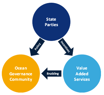
To this end, state parties in charge of developing and directing space policy & programmes should build closer links with ocean governance and conservation communities, to ensure a prosperous future for our oceans, maximize the role of space solutions in these efforts, and make strides in fully utilizing the power of space for the benefit of non-space policy priorities.
[1] Douglas McAuley, How Satellites and Big Data Can Help to Save the Oceans, YaleEnvironement360 (Link)
[2] ESPI would like to thank staff of the CLS Group for sharing their insights and expertise on the topic
[3] European Investment Bank, “The Clean Oceans Initiative” (2023), online: (Link); While the majority of projects funded to date target plastic waste generation, capture & recycling, the initiative is a testimony to the level of resources mobilized for ocean resilience. As the projects are implemented, monitoring will become an increasingly important element to determine the effectiveness of deployed resources.
[4] Ocean Risk and Resilience Action Alliance, “What We Do”, online: ORRAA (Link).